
價格:免費
更新日期:2017-05-16
檔案大小:233.2 MB
目前版本:5.2.2
版本需求:需要 iOS 8.0 或以上版本。與 iPhone、iPad 及 iPod touch 相容。
支援語言:法文, 義大利文, 英語, 西班牙文
ALL NEW FLYTOMAP Marine map with latest iOS Compatibility!
Introduces the new improved drawing system and updated data to your iPad devices for Navigation!
FLYTOMAP WATER MAPS (Marine):
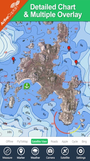
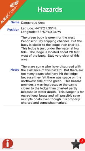
Water map navigator is the new ‘Marine Navigator for iPhone’ contains embedded Electronic Nautical Charts (ENC) from NOAA compressed to a large coverage. You can now download the application and transform your iPhone in a chart plotter with best NOAA, ENC S57 cartography; which includes Anchoring areas, Fishing areas, restriction areas, obstructions, rocks, Buoys, Beacons, Lights, Depth contours with Values display on map, Spot Soundings and more. The only marine app’s available in the market with such huge information. Every effort is made to be as accurate as possible when presenting information for every destination.
Use to Explore:

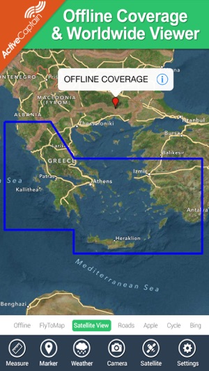
•NEW IMPROVED - OFFLINE MAP!
•GEO-COMPASS!
•DISTANCE MEASUREMENT TOOL!
•IMPROVED TRACK MANAGEMENT!
•GPS SIGNAL STRENGTH FINDER!
•Use Latitudes and Longitudes to go to your favorite places
•Insert the target/destination ‘Waypoint’ and see in real time your speed, distance and direction to destination.
•Insert Unlimited Markers near favorite places on the map
•Search your Favorite points directly
•Zoom, Rotate and Pan fast just by a finger touch

•Navigate and see your GPS position on the map
•Geo-Tagged photo management
"Continued use of GPS running in the background can dramatically decrease battery life."
支援平台:iPhone, iPad